SatelliteFootprintDetection
April 18, 2022 · View on GitHub
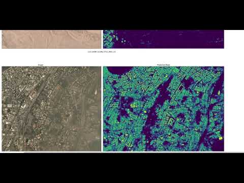
This Project's aim is Footprint Detection of Buildings in High-Resolution Satellite Images by using instance segmentation.
Dataset Characteristics:
- This open-source dataset includes 24 images (one per month) covering ~100 unique geographies.
- The dataset will comprise over 40,000 square kilometers of imagery and exhaustive polygon labels of building footprints in the imagery, totaling over 10 million individual annotations.
- The Data – ~100 locations, spread out across the globe and contains:
Dataset :
-
The Dataset is available for download on kaggle
-
The Dataset is available for download on AWS as a Public Dataset:
Training Data
- aws s3 cp s3://spacenet-dataset/spacenet/SN7_buildings/tarballs/SN7_buildings_train.tar.gz .
- aws s3 cp s3://spacenet-dataset/spacenet/SN7_buildings/tarballs/SN7_buildings_train_csvs.tar.gz .
Testing Data
- aws s3 cp s3://spacenet-dataset/spacenet/SN7_buildings/tarballs/SN7_buildings_test_public.tar.gz . Align center:


Models:
The Models trained are stored in GoogleDrive
BLOG POST:
The Whole Project is documented in this Blog Post
Results
Installation:
GIT:

.. code-block:: bash

  git clone https://github.com/PriyanK7n/SatFootprint
  cd SatFootprint
  pip install -r requirements.txt
  pip install -e .