location-conflation
April 29, 2026 · View on GitHub
![]()
![]()
location-conflation
🧩 Define complex geographic regions (geofences) by including and excluding country codes and GeoJSON shapes.
⚡️ Try it live at https://location-conflation.com/
What is it?
location-conflation generates GeoJSON features by combining other locations and shapes. It's a declarative way to describe geofences, so your application doesn't need to bundle or fetch large amounts of geodata.
A locationSet is an object with include and exclude arrays:
const locationSet = {
  include: [ /* locations */ ],
  exclude: [ /* locations */ ]
};
A location can be any of:
| Kind | Example |
|---|---|
| A country-coder identifier (ISO codes, UN M.49 codes, Wikidata QIDs, etc.) | "de", "001", "conus", "gb-sct", "Q620634" |
A custom .geojson filename (add custom features via the constructor or addFeatures) | "de-hamburg.geojson", "new_jersey.geojson" |
A circular area [lon, lat, radius?] (radius in km, defaults to 25) | [8.67039, 49.41882], [-88.3726, 39.4818, 32] |
Warning
For numeric-looking country-coder identifiers (for example UN M.49 codes), pass strings like "001" and "039".
Avoid using numeric literals in JavaScript, because leading-zero values may be treated like octal numbers and represent a different number than you expect.
Tip
The full list of recognized country-coder identifiers is browsable at https://ideditor.codes.
Installing
Node
npm install @rapideditor/location-conflation
The package is distributed as both CJS and ESM:
const { LocationConflation } = require('@rapideditor/location-conflation');   // CJS
// or
import { LocationConflation } from '@rapideditor/location-conflation';        // ESM
Browser
Fetch the IIFE bundle from the jsDelivr CDN. Loading it via <script> exposes a LocationConflation global:
<script src="https://cdn.jsdelivr.net/npm/@rapideditor/location-conflation@latest/dist/js/location-conflation.iife.min.js"></script>
<script>
  const loco = new LocationConflation();
</script>
Note
This project uses modern TypeScript syntax. If you need to support legacy environments like ES5 or Internet Explorer, build your own bundle with a tool like Babel.
Examples
import { LocationConflation } from '@rapideditor/location-conflation';
import myFeatures from './fixtures/features.json' with { type: 'json' };   // optional
const loco = new LocationConflation(myFeatures);
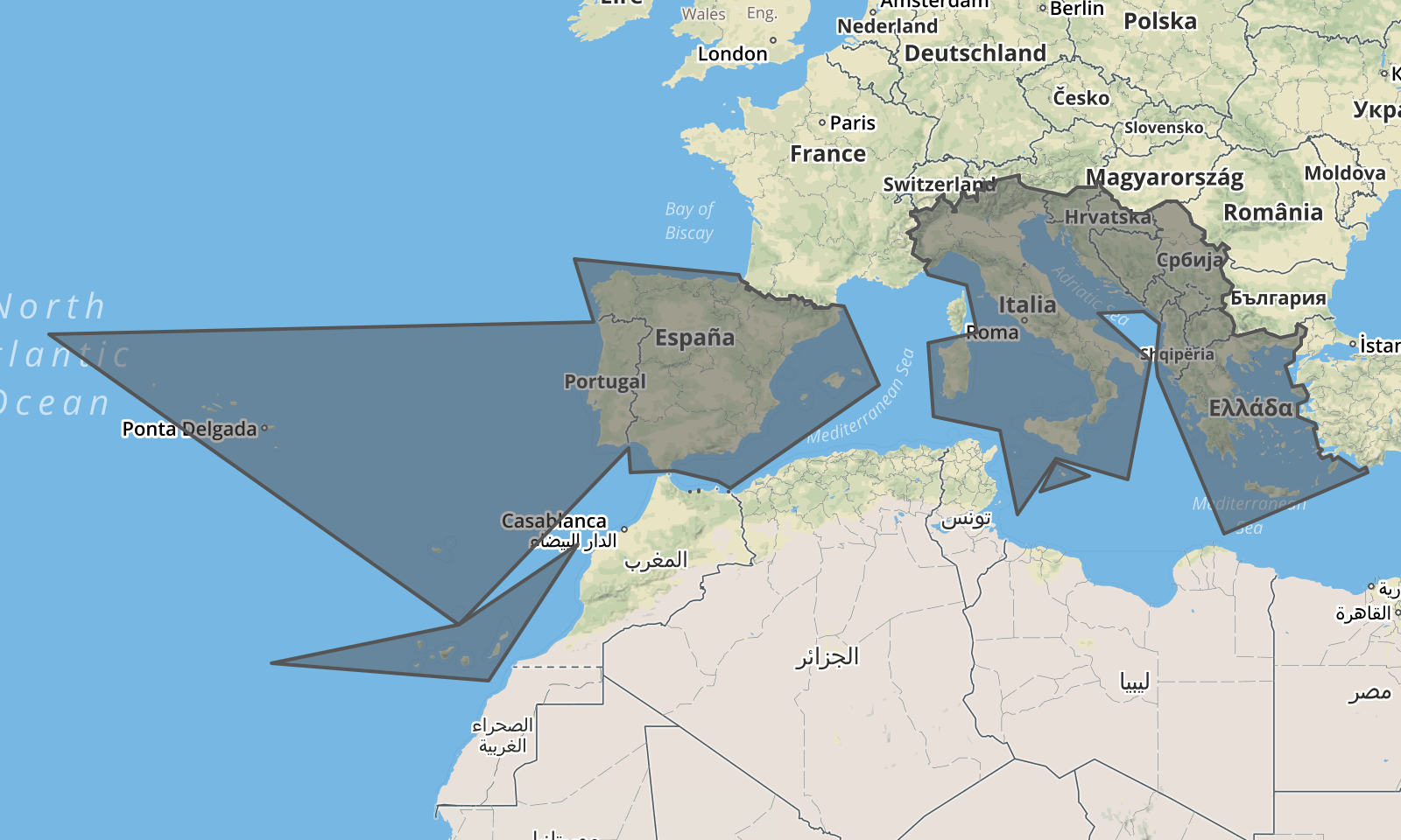
Southern Europe
const result = loco.resolveLocationSet({ include: ['039'] }); // 039 = Southern Europe
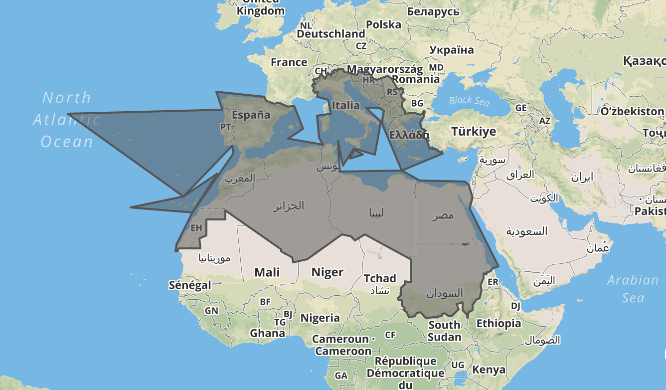
Southern Europe and Northern Africa
const result = loco.resolveLocationSet({ include: ['039', '015'] }); // 015 = Northern Africa
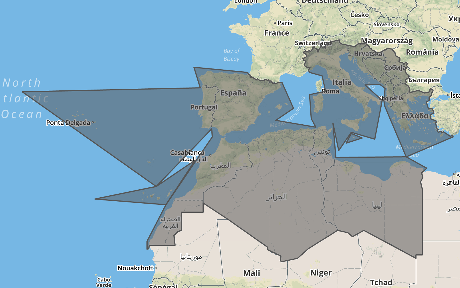
Southern Europe and Northern Africa, excluding Egypt and Sudan
const result = loco.resolveLocationSet({ include: ['039', '015'], exclude: ['eg', 'sd'] });
The Alps, excluding Liechtenstein and regions around Bern and Zürich
const result = loco.resolveLocationSet({
  include: ['alps.geojson'],
  exclude: ['li', [8.55, 47.36], [7.45, 46.95]]
});

Spatial index
If your application has many objects with locationSet values (e.g. presets, rules, rendering styles) and you need to test which of them apply at a given point, the spatial-index API makes that lookup fast.
Register your objects once:
const presets = [
  { id: 'amenity/cafe', locationSet: { include: ['de'] } },
  { id: 'amenity/atm',  locationSet: { include: ['001'] } },      // 001 = world
  { id: 'parking/bike', locationSet: { include: ['us-nj.geojson'] } },
];
loco.registerLocationSets(presets);
// Each preset now has a stable `locationSetID`, e.g. '+[Q183]'
Then query by point as often as you like:
const hits = loco.locationSetsAt([8.68, 49.41]);   // Heidelberg
// => Map { '+[Q183]' => 357386, '+[Q2]' => 511207893 }
if (hits.has('+[Q183]')) { /* Germany preset applies here */ }
Note
locationSetsAt does no polygon clipping — lookups are backed by country-coder's built-in spatial index for country-coder regions, and by which-polygon for custom .geojson and point-radius features.
Important
registerLocationSets is tolerant of bad input so a batch of thousands of objects won't be rejected over a single typo:
- Objects with a missing, empty, or invalid
locationSetfall back to world (+[Q2]). - Individual invalid
include/excludecomponents are silently ignored.
The single-item validate* / resolve* methods, by contrast, always throw on invalid input.
See the API reference for full details on registerLocationSets, locationSetsAt, rebuildIndex, and getLocationSetArea.
API
Full reference: API.md
| Method | Purpose |
|---|---|
new LocationConflation(features?) | Construct an instance, optionally seeded with custom .geojson features. |
addFeatures / removeFeatures / clearFeatures | Manage the custom feature cache. |
validateLocation / validateLocationSet | Validate without resolving geometry. |
resolveLocation / resolveLocationSet | Validate and resolve to GeoJSON (cached). |
registerLocationSets | Register locationSet-bearing objects for fast point-in-polygon lookups. |
locationSetsAt | Query which indexed locationSets cover a point. |
rebuildIndex / getLocationSetArea | Spatial-index maintenance / inspection. |
LocationConflation.stringify | Pretty-print GeoJSON with sensible defaults. |
Contributing
See CONTRIBUTING.md.
Thanks!
location-conflation is really a thin wrapper around these other great projects:
- country-coder — world boundaries
- polyclip-ts — polygon union / difference
- which-polygon — spatial index for custom shapes
License
Available under the ISC License. See LICENSE.md.